Coal tips to country parks walk
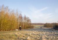
This 11-mile walk takes you on a route which passes through former coal mining sites which have now been transformed into woodlands and country parks, and by the picturesque Thornton reservoir.
The exploitation of deposits of coal – the famous ‘black gold’ – has been central to the region’s economy for centuries. Not only have the coalfields of Derbyshire and Leicestershire played a significant role in the history of British mining, but the industry that developed around them has shaped both the local landscape and the heritage of the people who live and work there.
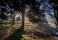
The landscape, once scarred with primary extraction of minerals, is now reclaimed for people and nature. This route gives a real sense of this transformational change, as you walk through ancient woodlands and historic sites which survived the ravages of industry, and onto new woodlands planted on new ground, linking the old and the new of the developing Forest.
Facilities
- Picnic Area
- Refreshments
- Walking
Location Map
Thornton Leicestershire
Directions
MAIN WALK AND SIX MILE LOOP:Starts at: Bagworth Heath Country Park car park, Heath Road, Bagworth, LE67 1DR
what3words: /// spinners.huddling.mega
ALTERNATIVE START POINT FOR SEVEN MILE LOOP:
Starts at: Thornton Reservoir Car Park, Reservoir Road, Thornton, Leicestershire, LE67 1AR
what3words: /// rider.twitching.sponsors
Points of Interest
Bagworth Heath Country Park
This is the site of the former Desford Colliery, where coal mining took place from 1902 to 1984. Reclamation works began in 1991 to transform a scarred industrial landscape into a valuable natural habitat. The country park includes lakes that were formed by mining subsidence and is planted with native tree species.
Royal Tigers Wood
Former soldiers from the Royal Leicestershire Regiment raised funds to plant Royal Tigers Wood. It includes tree species from the various countries in which the regiment (formerly the 17th Foot) won some of its important battle honours. A granite memorial stone at the top of the hill to your left bears the regimental cap badge and alongside is a Mercer’s oak, grown from an acorn from the tree in Princeton, New Jersey, around which the surrounded 17th Foot routed part of Washington’s army in a memorable battle in 1777.
Centenary Wood
Bagworth Parish Council celebrated its 100th anniversary by raising funds to plant Centenary Wood.
Bagworth Church
The new Holy Rood Church replaces the ancient Norman Church which collapsed as a result of mining subsidence. The new church stands on a floating foundation to prevent a recurrence and includes the salvaged Norman arch from the original building.
Bagworth Incline
The incline formed part of the Leicester to Swannington railway. The first public railway, this was engineered by George and Robert Stephenson in 1832. The toll-keeper’s roundhouse, which stood at the head of the incline, disappeared only a few years ago.
Bagworth Park
Bagworth Park farmhouse, built in 1769, stands on the site of Bagworth Moats, a grand house built in 1616 and which was surrounded by an impressive moat served by its own ferry boat. Parts of the overgrown moat are still visible near the house.
Old Hayes
The earliest reference to a dwelling at Old Hayes is 1280 and the present farmhouse dates back to 1733. It is a scheduled ancient monument and still retains the original moat, crossed by a bridge with a 15th Century dovecote within. Old Hayes woodland was planted in 2008/09.
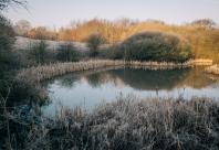
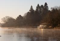
Thornton Reservoir
Thornton derives its name from an old reference to the vegetation that grew wild around the village; thus “Town of Thorns” or Thornton. The reservoir was created in 1854 to supply Leicester with drinking water, which had previously relied on wells and springs. It is now a refuge for a diversity of wildlife and an important site for waterfowl, and was designated a Local Wildlife Site in 2005.
Martinshaw Wood
Thought to have been mentioned in the Domesday Book as a wood lying within the Manor of Groby, it was later established as a wooded enclosure in a deer park in the 13th century. The estate sold timber to the local economy and quarrying industry and was more recently planted with conifers. An extensive historical survey uncovered archaeological features including a possible Iron Age enclosure, banks and earthen dams across streams and a sunken track which appears to run towards ancient stone quarries.
Image Gallery