Mythaholme to memorials walk
This six mile walk explores some of the older and more recent history of part of the Trent Valley.
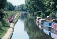
It passes mediaeval earthworks, the 18th century Trent and Mersey canal, 19th and 20th Century mineral workings and the 21st Century plantings of the National Memorial Arboretum, themselves commemorating recent history.
Location Map
The National Memorial Arboretum Croxall Road, Alrewas Burton-on-Trent DE13 7AR Staffordshire
Directions
Starts at: National Memorial Arboretum, Croxall Road, Alrewas, Staffordshire, DE13 7AR (parking charges apply)what3words: /// grid.investors.dizzy
Points of Interest
The National Memorial Arboretum
This 60 hectare (150 acre) site is managed by the Royal British Legion and was conceived as a living tribute to service men and women who have lost their lives in the 20th-century; a period marked by global conflicts. Planting began in 1997 and the centre was opened in 2001. There are now over 400 memorials sited within a woodland setting of over 25,000 trees.
Alrewas
Alrewas is one of the oldest recorded communities in the Midlands, and there has been a church here since 822. It was a fording point of the rivers Tame and Trent on an important trading route. The village developed to support the trade people, especially during times of flood. In medieval times, a salt road from Cheshire to London passed through Alrewas; and the A38 to the east of Alrewas follows the route of Ryknild (or Ickneild) Street, a Roman road.
In ancient documents, the village name was written as Allerwas or Alderwasse, which comes from ‘aldr’ (alder) and ‘waesse’ (marsh). Alrewas was famed for its eel fishery, and basket weaving was a thriving cottage industry, using osiers that grew plentifully alongside the river. Alder trees still thrive along the river and canal.
Wychnor
The east arch of the tower of St Leonard’s Church, Wychnor dates back to 1200 AD, and the rest of the building from the 14th century. The lost mediaeval village of Wychnor is on the higher ground opposite the church. A sluice near Wychnor lock carries water under the A38 along a channel that served Wychnor forge, which operated from 1764 to 1781.
Gravel workings
The rich sand and gravel deposits in the Trent Valley have been extracted since the 19th Century. Barton Quarry, owned by Hanson Aggregates, covers nearly 300ha. The railway bridge here is a favourite haunt of trainspotters.
The rich sand and gravel deposits in the Trent Valley have been extracted since the 19th Century. As the gravel extraction ceases, these areas will be gradually returned to nature and provide a new wetland habitat, like at Tuckleshome and Croxall Lakes Nature Reserve. These gravel pits have produced important archaeological finds dating back to the ice age, including the remains of a woolly rhino, mammoth, reindeer, wild horse and a wolf as well as plants and beetles.
Mythaholme
The Mythaholme footbridge was opened in 2004. Mythaholme comes from the Old English meaning the mouth of a river where it runs into another or a confluence of rivers.
If you are very lucky, you may see otters on the river. But even if you don’t, look out for other wildlife on this quiet stretch. As the path bends to the right, you look across to Croxall Lakes Nature Reserve, which supports a variety of birds and other wildlife.
Off route highlight
Croxall Lakes Nature Reserve was a sand and gravel quarry and is part of a complex of restored wetlands in the Trent valley. Owned by Staffordshire Wildlife Trust, parts of the river have been re-profiled in a process known as 'river braiding', which helps to restore natural river processes and improves wildlife habitat. Visit the Trent Valley Noon Column on the lakeside, a short walk from the car park: a 3-metre-tall oak sculpture, designed by internationally renowned artist David Nash.
Image Gallery